OpenStreetMap is a new application to me, one that we are exploring in our Digital Humanities class. It is a very beneficial open source mapping tool that lets anyone map any part of the world. Using satellite imagery from Bing and other mapping techniques, you can map any place on the planet. As quoted from the OpenStreetMap Wiki, “We started this project because most maps you think of as free actually have legal or technical restrictions on their use, holding back people from using them in creative, productive, or unexpected ways” (OpenStreetMap Wiki, 2014), and with this mindset many great things have come from using OSM. For our assignment we were to use OpenStreetMap, either to map our own neighbourhood or to explore the Humanitarian OpenStreetMap Team (HOT) task manager site, and pick from the many projects that they are working on. I chose to work on some of the Humanitarian projects currently going on around the world, and I am glad it did.
It really brought to light the kind of struggles going on in more disadvantaged areas of our planet and what help is needed to combat the many problems in these areas. I chose to map areas in Nigeria that needed state roads mapped to help with the delivery of vaccines and plan new vaccination campaigns. All they were looking for on this project was to map and class all the roads in the Imo state in Nigeria with the tags available. They gave good instruction and help in determining the class of the roads in Nigeria and gave links to Nigeria Wiki Project and Highway Tag Africa on the OpenStreetMap Wiki to offer a hand figuring out different road classes. If you were ever in doubt you could always just check on one on the validated block to see how they classed certain types of roads or how they classed their buildings.
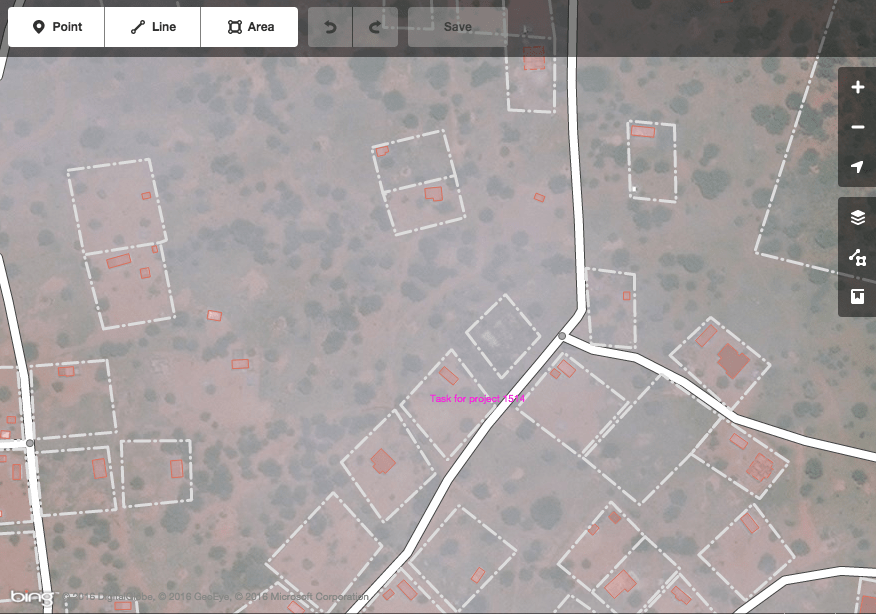
Screenshot of an area of Sefhare in Botswana that I Validated
The other project I worked on was in Botswana, and that project entailed mapping buildings and roads to help Sefhare primary hospital with their connection to the 15 neighbouring clinics and hospitals and to better understand patient demographics. In this Project they were looking for people to map all roads as far as you could follow them and use the Highway Tag Africa Wiki to class them and map all the buildings and compound walls. As well as mapping a few tiles, I also validated a couple of tiles on this project. From the tiles I validated I found there was not much that was wrong or missed by the people who worked on them. I came across a few compound walls not done and one or two roads missed, but overall I found the work done by others to be quite accurate. Overall from the two projects I worked on I found the experience enjoyable and informative however I did have a few issues in certain areas. Firstly I had problems working with OpenStreetMap in my default browser Safari. When I was entering a tile to start work on a project, the map would come up black or it might be there but if I zoomed in on the map it would disappear. It kept happening so I switched over to Google Chrome instead (which I don’t like using on my computer), however it worked perfectly with Google Chrome and had no issues after that.
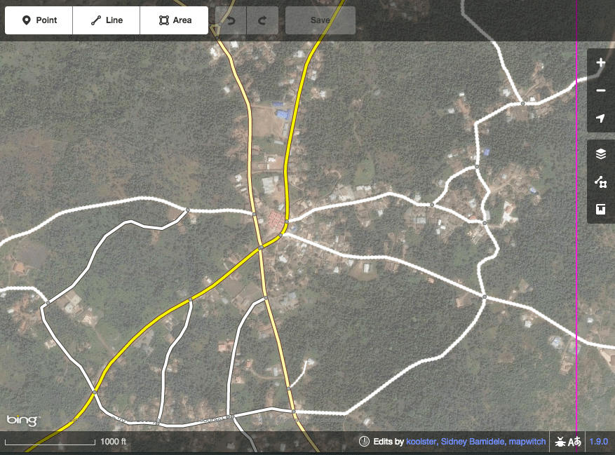
Screenshot of an area of Imo State in Nigeria that I was Mapping
The other issue I came across that annoyed me was while I was mapping tiles in Nigeria. While working on a tile with a lot of information that needed to be mapped, I decided to call it a night and finish it off the next morning. However when I went back to it the next morning it had been marked as done. I took a look at what was changed in the tile and since everything in the tile was done by me, I saw the whoever had marked it as done had not contributed anything and was just going around to tiles that were nearly finished, marking them as done and taking credit for other people’s work. This is one of the flaws I came across in using OpenStreetMap, but this is the case for every open contributed system, not everyone has good intentions at mind. In the end we are not doing this to get credit but to contribute to the good cause that helps a lot of people. I do think the majority of people using OpenStreetMap are there to help create a very useful open map of the world that everyone can benefit from. When working on these projects, it kept popping into my head, “was I doing it right?”. What happens if I miss a road or a building because the image is blurry or I don’t think it is of importance, will someone see the mistake and fix it or will it stay that way. Since you are working on humanitarian projects how would your mistake impact on real life, would a truck carrying important medicines get lost down so trail because I marked it as a main road? I think you have to believe that everything you do will be checked by someone more experienced than you and even after a tile is validated that they still would check people’s work before they sign off on a project. I looked back at few of my tiles I had done and that someone else had validated to see what changes had been made. In one tile it looked like nothing was changed even though I think looking back maybe I made a mistake or two on classifications of roads and on one of the other tile someone had taken most of my work off that I think was right. So it is hard to know how they judge these things but I would say I will be checked by someone more experienced anyway.
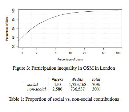
Courtesy of a study by D Hristova, G Quattrone, A Mashhadi and L Capra
I came across an interesting study done on the “Impact of Social Mapping in OpenStreetMaps” that looked at what effect mapping parties has on the contribution to OSM. They found in their study that mapping parties in London (the area where they studied ) were contributing a lot to OSM. Social user of which there were 150 participants were responsible for 70% of the OSM content while the 2,586 non-social participants made up the other 30% (D Hristova, G Quattrone, A Mashhadi and L Capra, 2013). These numbers are staggering and show that social engagement while mapping is a great way to get into OSM. You could question the quality of the work done in these mapping parties, with maybe a lot of newcomers doing it for the first time. However I would think that with people there to support each other and help out if any needs a second set of eyes that it would actually promote better mappers in the long run.
Using OpenStreetMap has been an interesting learning experience from me, and one I hope I can keep contributing to in the future. Learning more about mapping and what you can do with maps is an area I want to improve in, but I got a lot more than just learning to map out of this assignment. Choosing the humanitarian projects opened me up to the struggles in far off areas of the world and what is actually needed for them to keep going. It also taught me more about the infrastructure of these countries, and how to classify their road networks. It is good to know there are ways of joining in a good cause and helping people in need even though you are far from the areas in question.
My experience with using OpenStreetMap has given me more knowledge and interest in working with spatial data and GeoWiki’s. Like with my review of WorldMap, which lets you represent data on maps. This is along the same lines but brings into it a sense of you are helping impact the world in a positive way through the humanitarian projects. I will continue to use OpenStreetMap with the hope of getting better at mapping and moving up to a more advanced editor like JOSM, as I think learning more about GIS would greatly benefit me when pursuing related projects in the future.
The other spatial data tools mention in our Digital Humanities class has given me a bigger idea of the different ways you can use geo-spatial data to have a positive impact on society. The likes of The flow towards Europe and GaugeMap are very interesting and helpful ways of using spatial data to help or inform people of certain situations. I would like to work on creating projects like these in the future, I just need to start using these kinds of tools more and get a grasp on how to collect and present information in interesting ways.
Bibliography:
- D Hristova, G Quattrone, A Mashhadi and L Capra,“The Life of the Party: Impact of Social Mapping in OpenStreetMap” Accessed March 3, 2016. https://www.cl.cam.ac.uk/~dh475/papers/icwsm13.pdf
- Humanitarian OpenStreetMap Team. Humanitarian OpenStreetMap Team #mapthedifference. Accessed March 4, 2016. https://www.youtube.com/watch?v=8wdzGKmZu-k.
- “OpenStreetMap Wiki.” Accessed March 2, 2016. https://wiki.openstreetmap.org/wiki/Main_Page.
Leave a Reply